


PRECINCT HUDSON 4-D, Summit County, Ohio
About
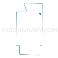
Outline

Summary
| Unique Area Identifier | 652093 |
| Name | PRECINCT HUDSON 4-D |
| County | Summit County |
| State | Ohio |
| Area (square miles) | 0.53 |
| Land Area (square miles) | 0.52 |
| Water Area (square miles) | 0.02 |
| % of Land Area | 97.00 |
| % of Water Area | 3.00 |
| Latitude of the Internal Point | 41.26039240 |
| Longtitude of the Internal Point | -81.41763070 |
Maps

Graphs
Select a template below for downloading or customizing gragh for PRECINCT HUDSON 4-D, Summit County, Ohio


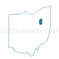
Neighbors
Neighoring Voting District (by Name) Neighboring Voting District on the Map
- PRECINCT HUDSON 1-A, Summit County, OH
- PRECINCT HUDSON 1-F, Summit County, OH
- PRECINCT HUDSON 3-A, Summit County, OH
- PRECINCT HUDSON 3-B, Summit County, OH
- PRECINCT HUDSON 4-C, Summit County, OH
- PRECINCT HUDSON 4-E, Summit County, OH
- PRECINCT HUDSON 4-F, Summit County, OH